No Warnings, Watches, or Advisories
Highslide JS Highslide JS
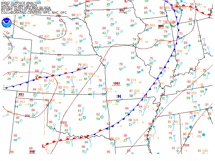
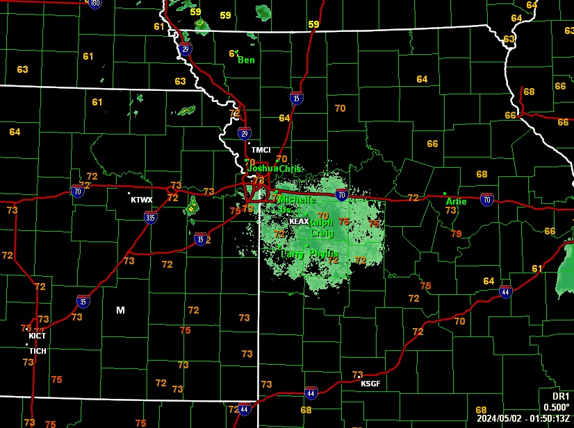
Satellite map courtesy of NOAA|NESDIS|STAR and Surface map courtesy of NOAA WPC
spacer
METRIC | IMPERIAL
Updated: 18-May-2024 @ 9:44pm   (0 sec ago)
Temperature Current Conditions Forecast / Storm Prediction
Currently Outside: Colder 3°F than last hour.

78.3°F

Comfortable
High Today
87.9°F
5:11 PM
Low Today
62.1°F
6:46 AM
Yest High
83.7°F
3:48 PM
Yest Low
59.7°F
6:26 AM
Sta* High
85.9°F
2018
Sta* Low
45.0°F
2010
Same Time Yesterday
72.4°F
Change Last Hour
Colder 3°F than last hour.3°F
* This Station's Records Since 9/2007
Station Record High
Dry Dry
Wind from SW Wind: 
SW
0.3

Current Rain Rain:
0.00 in
Chandler Burning Index: LOW Current CBI
Fire Danger:
7.8 of 100
Tonight

Tonight: Mostly Clear
Mostly Clear
Sunday

Sunday: Sunny
Sunny
Sunday
Night
Sunday Night: Chance Showers And Thunderstorms
Chance Showers And T-Storms
Lo 64°F Hi 86°F Lo 66°F
SPC Activity Map
Dew Point Liquid Precipitation Wind Speed Sun/Moon
Current: Decreased 0.6°F since last hour. 65.1°F
Last Hour: Decreased 0.6°F since last hour. 0.6°F
High 5:18 PM: 69.2°F
Low 6:23 AM: 58.8°F
Record High: 84.4°F on
Aug-21-2023
Record Low: -16.4°F on
Jan-14-2024
Wetbulb: 69.9°F
Today: 0.00 in
Yesterday: 0.00 in
Last 7 Days: 0.48 in
May Rain: 2.76 in
May to Date
  Avg:
0.00 in
May to Date
  Diff from Avg:
Over 2.76 in for the month 2.76 in
May Avg: 5.99 in
Diff from Avg: Under 3.23 in for the month 3.23 in
Season: 14.06 in
YTD
  Avg:
8.79 in
YTD
  Diff from Avg:
Over 5.27 in for the year 5.27 in
Last Rain
Time/Date:
May-16-2024
at 5:09 AM
Rainy Days:
32 days of rain in 2024
11 days in May
1 day since last rain


Current: SW  0.3 mph
1Hr Average: 0.4 mph
Wind Run: 32.35 miles
Wind Gust
Current: 1.0 mph
Today: 19.6 mph 2:13 PM
Month: 37.0 mph May-6
Year: 25.0 mph May-9
Record Gust: 90.9 mph
Feb-21-2013
Sunlight:
14 hrs 19 min
24 sec
of Sunlight Today
Which is
1 min 34 sec longer than
yesterday
(Noon) graph (Midnight)

Legend

Waxing Gibbous
Waxing Gibbous, 10 days, 23 hours, 23 minutes in cycle
82%
Illuminated
Humidity Barometer
Current: Increased 5% since last hour. 64%
Last Hour: Increased 5% since last hour. 5%
High 7:12 AM: 92%
Low 3:19 PM: 46%
High Humidex : 102.5%
Low Humidex : 69.3%
Current: Rising 0.021  inHg/hr 29.670 inHg
Last Hour: Rising slowly
High 9:42 PM: 29.671
Low 3:02 AM: 29.553
Record High: 31.066 inHg
Jan-7-2015
Record Low: 28.547 inHg
Mar-3-2024
Cooling Degree Days Snow Heat Index Air
Today: 3.7
May: 29.3
2024 to Date: 68.3
Heating Degree Days
2024 to Date: 2399.6
Today: 0.00 in
Yesterday: 0.00 in
May Snow: No Change 0.00 in
May Avg: 0.00 in
Diff from Avg: 0.00 in
Season Total: 12.60 in
Snow Depth: 0.00 in
0 snow days in May
4 snow days this season.
Average 1st Snow:
0
Current: 80.2°F
High 5:18pm: 92.4°F
Yesterday: 85.5°F
Record: 128.8°F
Aug-20-2023
Quality
Index:

39


Good
Density:
1.16 kg/m
UV Summary/Forecast Solar Summary
High Today:   6.7 @ 12:59 PM
May-19

7.9
May-20

8.0
May-21

7.5
High Today:  
991 W/m @ 1:15 PM
Sun Hours Today:
00:00
   This Month: 00:00 Hrs
Rise: 6:01 am  Set: 8:26 pm
Almanac Irrigation Index Station All Time Records Cloud Level
Currently: Evening
YTD Avg Temp: 48.2°F
Sunrise: 6:01 am
Sunset: 8:26 pm
Moonrise: 4:56 pm
Moonset: 3:55 am
Full Moon: May-23-2024
New Moon: 12:38 UTC
Jun-06-2024

Updated at Midnight
Current ET: 0.00 in
7-Days Rain: 0.48 in
7-Days ET: 0.05 in
7-Day:  0.429 in water in excess of what evaporated in last 7 days. 0.429 in
May:  2.71 in water in excess of what evaporated this month. 2.71 in
HIGHS: LOWS:
108.0°F
Aug-2-2011
-8.3°F
Jan-14-2024
Daytime Records
  105.3°F°F
Aug-02-2011
  -5.1°F°F
Dec-22-2022
Nitetime Records
  92.7°F°F
Jul-28-2011
  -6.2°F°F
Jan-14-2024
ICN:1 | S3C2:1 | Ajax 3.xx
ISS:Ok | CON:4.6 | RCP:100%
 NWS Weather Forecast  -   Outlook Tonight & Sunday
Tonight

Tonight: Mostly Clear
Mostly Clear

Lo 64°F
NWS forecast: Mostly clear, with a low around 64. West wind around 6 mph.
Sunday

Sunday: Sunny
Sunny

Hi 86°F
NWS forecast: Sunny, with a high near 86. Southeast wind 6 to 13 mph, with gusts as high as 22 mph.
 NWS Short Term Weather Forecast
Sunday
Night
Sunday Night: Chance Showers And Thunderstorms
Chance Showers And T-Storms
Monday

Monday: Chance Showers And Thunderstorms
Chance Showers And T-Storms
Monday
Night
Monday Night: Chance Showers And Thunderstorms
Chance Showers And T-Storms
Tuesday

Tuesday: Chance Showers And Thunderstorms
Chance Showers And T-Storms
Tuesday
Night
Tuesday Night: Showers And Thunderstorms Likely
Showers And T-Storms Likely
Wednesday

Wednesday: Slight Chance Showers And Thunderstorms
Slight Chance Showers And T-Storms
Wednesday
Night
Wednesday Night: Slight Chance Rain Showers then Mostly Clear
Slight Chance Rain Showers then Mostly Clear
Lo 66°F Hi 86°F Lo 69°F Hi 87°F Lo 55°F Hi 73°F Lo 53°F
Modified ajax-dashboard6.php - Version 6.95h - 20-Feb-2023 - Script by: Scott of BurnsvilleWeatherLIVE.com
Now supported by Saratoga-weather.org Download