
| STORM REPORTS Issued by the Storm Prediction Center |
| Select date for other reports |
June 14, 2025 |
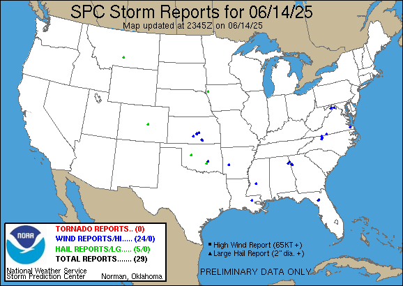 |
| 29 reports sorted by the latest reports first |
| Jun 14 6:26 pm CDT |
| COLORADO - El Paso COUNTY - 5 MILES NORTHEAST OF Manitou Springs |
| HAIL - 1.00 in - (Pueblo, CO) |
| Jun 14 6:20 pm CDT |
| OKLAHOMA - Custer COUNTY - 3 MILES EAST-NORTHEAST OF Thomas |
| HAIL - 1.75 in - (Oklahoma City, OK) |
| Jun 14 6:20 pm CDT |
| MONTANA - Sweet Grass COUNTY - 12 MILES WEST-NORTHWEST OF Rapelje |
| HAIL - 1.25 in - (Billings, MT) |
| Jun 14 5:55 pm CDT |
| IOWA - Plymouth COUNTY - 1 MILE SOUTHEAST OF Le Mars |
| HAIL - 1.25 in - Infrequent larger stones from quarter to half-dollar size. (Sioux Falls, SD) |
| Jun 14 5:29 pm CDT |
| WEST VIRGINIA - Hampshire COUNTY - 3 MILES SOUTH-SOUTHWEST OF Capon Bridge |
| WIND - Trees blew down in the 2900 block of CR-14 Capon River Road. (Baltimore/Washington D.C.) |
| Jun 14 5:08 pm CDT |
| VIRGINIA - City of Suffolk COUNTY - 3 MILES EAST-SOUTHEAST OF Wilroy |
| WIND - Multiple trees knocked down along US-58 East. Time estimated from radar. (Wakefield, VA) |
| Jun 14 5:08 pm CDT |
| WEST VIRGINIA - Hampshire COUNTY - 3 MILES SOUTH-SOUTHEAST OF Slanesville |
| WIND - Trees blew down near the intersection of CR-45/20 Cold Stream Road and CR-4/2 North River Mills Road. (Baltimore/Washington D.C.) |
| Jun 14 4:52 pm CDT |
| MISSISSIPPI - Hinds COUNTY - 2 MILES NORTH-NORTHWEST OF Jackson |
| WIND - A tree was blown down onto powerlines on Maple Street in Jackson. (Jackson, MS) |
| Jun 14 4:50 pm CDT |
| WEST VIRGINIA - Berkeley COUNTY - 1 MILE NORTH OF Ridgeway |
| WIND - Trees blew down in the 1900 block of CR-24/1 Sam Mason Road between I-81 and US-11 Winchester Avenue. (Baltimore/Washington D.C.) |
| Jun 14 4:40 pm CDT |
| GEORGIA - Polk COUNTY - 2 MILES SOUTH OF Antioch |
| WIND - Trees down along Grady and Hightower Mountain Rd. (Atlanta, GA) |
| Jun 14 3:50 pm CDT |
| GEORGIA - Polk COUNTY - 2 MILES WEST OF Antioch |
| WIND - Trees down along Antioch Rd. (Atlanta, GA) |
| Jun 14 3:35 pm CDT |
| ARKANSAS - Montgomery COUNTY - 1 MILE NORTHWEST OF Mount Ida |
| WIND - A few trees and powerlines blown down just north of town on 270 N. (Little Rock, AK) |
| Jun 14 3:18 pm CDT |
| ALABAMA - Cherokee COUNTY - 3 MILES NORTH-NORTHEAST OF Waterhouse |
| WIND - Tree down at Highway 9 and County Road 121. (Birmingham, AL) |
| Jun 14 2:57 pm CDT |
| ALABAMA - Cherokee COUNTY - 1 MILE SOUTHWEST OF Centre |
| WIND - Tree and power line down in Centre. (Birmingham, AL) |
| Jun 14 2:30 pm CDT |
| FLORIDA - Alachua COUNTY - 5 MILES NORTH OF Archer |
| WIND - Fallen tree on SW 170th Street lead to temporarily closure. Time based off radar and report. (Jacksonville, FL) |
| Jun 14 2:05 pm CDT |
| VIRGINIA - Henry COUNTY - 3 MILES SOUTH-SOUTHWEST OF Martinsville City |
| WIND - Henry County 911 Call Center reported a tree down blocking one lane on Cameron Road in Martinsville... VA. (Roanoke, VA) |
| Jun 14 1:28 pm CDT |
| NORTH CAROLINA - Yadkin COUNTY - 1 MILE NORTH OF Yadkinville |
| WIND - Tree down... blocking one lane of Country Club Road. (Roanoke, VA) |
| Jun 14 1:18 pm CDT |
| NORTH CAROLINA - Surry COUNTY - 1 MILE EAST-NORTHEAST OF Siloam |
| WIND - Delayed Report: Surry County 911 Call Center reported that two trees are down on Hardy Road in Siloam... NC. Time is estimated from radar. (Roanoke, VA) |
| Jun 14 1:05 pm CDT |
| OKLAHOMA - Pontotoc COUNTY - 4 MILES EAST OF Ada |
| HAIL - 1.00 in - Report from mPING: Quarter (1.00 in.). (Oklahoma City, OK) |
| Jun 14 1:00 pm CDT |
| NORTH CAROLINA - Surry COUNTY - 2 MILES SOUTH-SOUTHEAST OF Flat Rock |
| WIND - Surry County 911 Call Center reported a tree down near the intersection of Massey Road and Saint Marie Trail in Mount Airy... NC. Time is estimated from radar. (Roanoke, VA) |
| Jun 14 12:40 pm CDT |
| OKLAHOMA - Hughes COUNTY - 4 MILES SOUTH-SOUTHEAST OF Holdenville |
| WIND - Tree blown down at Holdenville Lake. Time estimated from radar. (Oklahoma City, OK) |
| Jun 14 12:00 pm CDT |
| LOUISIANA - Livingston COUNTY - 1 MILE NORTHEAST OF Walker |
| WIND - Tree down on Moore Ave in Walker. (New Orleans/Baton Rouge, LO) |
| Jun 14 11:45 am CDT |
| FLORIDA - Alachua COUNTY - 7 MILES WEST OF University of Flori |
| WIND - Road closed at the intersection of W Newberry Rd and NW 120th Terrace in Gainesville due to a fallen tree and downed power lines. Time est. based off radar. (Jacksonville, FL) |
| Jun 14 9:15 am CDT |
| KANSAS - Cowley COUNTY - Udall |
| WIND - 60 mph - (Wichita, KS) |
| Jun 14 9:04 am CDT |
| KANSAS - Sumner COUNTY - 5 MILES WEST-NORTHWEST OF Udall |
| WIND - 70 mph - (Wichita, KS) |
| Jun 14 8:05 am CDT |
| KANSAS - McPherson COUNTY - 5 MILES WEST-NORTHWEST OF Moundridge |
| WIND - 65 mph - (Wichita, KS) |
| Jun 14 7:51 am CDT |
| KANSAS - Reno COUNTY - 5 MILES NORTH-NORTHEAST OF Hutchinson |
| WIND - 63 mph - (Wichita, KS) |
| Jun 14 7:46 am CDT |
| KANSAS - Reno COUNTY - KHUT |
| WIND - 62 mph - (Wichita, KS) |
| Jun 14 7:27 am CDT |
| KANSAS - Reno COUNTY - 3 MILES WEST-SOUTHWEST OF Langdon |
| WIND - 60 mph - (Wichita, KS) |
|
Daily reports from the Storm Prediction Center starts at noon UTC and ends at one minute before noon UTC the next day. This time period is between 7am CDT and one minute before 7am CDT the next day.
All reports are considered preliminary and should be treated as such. |